
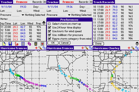
Born out of a need to keep abreast of what the latest tropical depression/tropical storm/hurricane is doing, I created Tracker, a Palm OS application for keeping up with the whereabouts of the latest storm. Being that I am a Florida resident, the map covers the Atlantic basin with a displayable area of 10 - 50 degrees latitude and 60 - 100 degrees longitude. You can enter wind speed using MPH or knots and pressure using either inches of mercury or millibars. The category of the storm can be automatically determined from the wind speed. On the map, the different category strengths are repesented by different colors.
You can also get many more additional hurricane databases here that Greg Marrs put together using Tracker 4.1. These can be loaded right in the application for your perusal. Thanks much Greg!
Compatibility
| Device: | All |
| OS: | 3.03.54.05.05.4 |
Download
| Version | File | Size |
|---|---|---|
| 4.8 | Tracker_4.8.zip | 76K |








comments